
Beaches at Risk: Coppe Study Reveals Real Threat to Rio de Janeiro’s Shoreline
Planeta COPPE / Civil Engineering / News
Date: 03/07/2025
Imagine a future without the sandy stretches of Copacabana or Ipanema. No space to lay out a towel, walk along the shore, or simply admire the ocean. This scenario, which may seem dystopian, is precisely the warning brought by a groundbreaking study from Coppe/UFRJ, published in the journal Natural Hazards.
The result of research led by specialists from Coppe’s Civil Engineering Program, the study presents highly detailed projections of the impacts of sea level rise in the Rio de Janeiro region — one of the most vulnerable areas along Brazil’s coastline. And what it reveals is alarming: urban beaches could disappear irreversibly by the end of the century.
Science with impact: novel modeling and alarming results
Using the ROMS (Regional Ocean Modeling System) coupled with a high-precision Digital Elevation Model, the researchers simulated the effects of sea level rise — projected to reach up to 69 centimeters by 2100 — on Rio’s coastal and urban areas. This approach, unprecedented in Brazil, offers a localized view that takes into account factors such as land use, bathymetry, tides, and environmental characteristics. “Global projections do not address coastal flooding in detail. The regional model allows us to capture specific dynamics, such as currents, tides, and sea level changes over time — aspects that global models cannot reflect,” explains researcher Raquel Toste, one of the study’s authors.
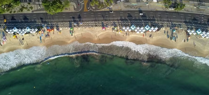
Beaches like Copacabana and Ipanema at risk
The study indicates that neighborhoods such as Copacabana, Ipanema, Leme, Leblon, Botafogo, and Flamengo are among the most threatened. In many cases, there is no physical space for the beach to migrate as the sea advances, which could lead to the complete loss of these recreational areas and cultural landmarks.
In addition, the simulation shows a concerning increase in the extent of coastal lagoons, such as Lagoa Rodrigo de Freitas and Lagoa de Piratininga, as well as the risk of disappearance of the remaining mangroves in Guanabara Bay — ecosystems that are crucial for environmental balance and flood control.
More than a warning, the study, conducted by the Laboratory of Computational Methods in Engineering (Lamce), provides a strategic tool for public policy. Even under the most optimistic climate scenarios — with global warming stabilized by 2100 — the impacts on Rio’s coastline will be inevitable if local adaptation measures are not adopted immediately. The detailed analysis of areas most susceptible to flooding, including the frequency, depth, and duration of inundation, makes it possible to: map real risk zones; guide investments in drainage and containment infrastructure; evaluate engineering solutions for beach preservation; plan the relocation of vulnerable communities; and protect coastal ecosystems under threat.
Science that guides decisions
This study demonstrates that facing the climate crisis requires actions grounded in data, science, and long-term planning. Coppe’s research reinforces the strategic role of public universities in generating applied knowledge, with direct potential to inform public policies, protect vulnerable populations, and preserve the city’s environmental and cultural heritage.
- Climate Change
